It looks like you are using an ad blocker. That's okay. Who doesn't? But without advertising revenue, we can't keep making this site awesome. Click the link below for instructions on disabling adblock.
Welcome to the Newschoolers forums! You may read the forums as a guest, however you must be a registered member to post.
Register to become a member today!
The snow should stay untouched up there pretty much, and should stay nice for q long time. It's north facing, out of the sun.
We'll get togethr a small group and go slay the place for sure. It'll be a bitch breaking ground and hiking it with all the untouched snow, but it'll be well worth the effort.
Yea, for that much vertical if its nice powder, I'd have to hit the person to say it's not worth it. You don't get that at KB. Are the trails still decent though? I don't want to hit a random log somewhere and die.
I saw one down tree, which would be obvious and all you would need to do is lean back. I remember where it was too. It was in this steeper, tight narrow trail.
i have this old boeri silver gumball helmet. I tested it out the other day, and if i tape and tie my small dv cam to one side and a 1 lb object on the other side to balance out the weight i have a helmet cam.
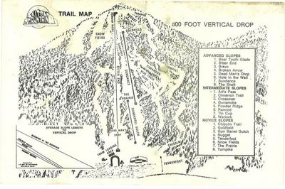
man i need to get use to 800' be a lot of verticle. You guys need to come upstate sometime, and go to gore or whiteface sometime. It should be fun though if we get some good dumps. What do you guys typically get for good lake effect storms?
A good dump is 2+ feet overnight. We get a fair share of 12"+ days though with the Lake effect until the lake freezes over.
During those storms we will routinely see 2"+/hour snowfall rates. Only drawback is that they are very localized and a few miles away it will be sunny. But that area from KB to Holiday Valley, which includes Bluemont are the most common areas for solid snowfall totals during lake effect storms. There was a day last season where me, mills and Connor were poaching twister at KB during a big storm, and getting thigh deep powder.
Whiteface seems to have awesome terrain, but their average annual snowfall seems pretty bleak.
There's definitely some good pitch to the hill. I wish I had the pictures uploaded, but I never got tem off the camera, let alone resized them and hosted them
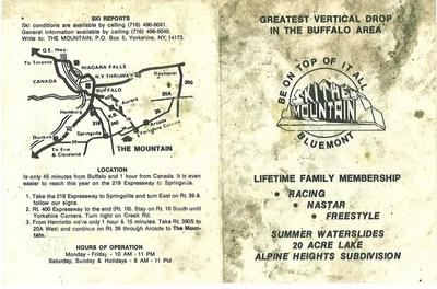
The area seems to still be eyed up by developers, which I can see why. Good snowfall, elevation, north facing for a long season, best vertical in the area.
Nothing ever becomes of it though and it just continues to sit there.
And wow, those contour lines on the east side of the hill are pretty tight. That's all wooded, but if it's old growth and well psaced, could be worth checking into.
Yea, hiking it is a bitch, luckily I am getting some skins soon. I have heard rumor of a road around the backside to the top, I'll look into that for you guys. I'll join you if its skiable while I am home.
Coming off the road, though I haven't checked out the topo yet either. If the road is right near the peak it may not be so bad. I might check it out at Thanksgiving if I have a chance. I don't think those roads get plowed very well either, and if the road behind it is the one I think it is, it will be a bitch with snow.
A few years ago in Springville, just after the expressway ended, you drive through that strip of stores and stuff, on the right side there was a building that had two chairlift poles set up with a chair hanging in the middle. They were attempting to do something with it for a while.
Well, the topo pegs the steep shit on that area of the hill. The road goes halfway up the hill.
I'll have my Subaru outback with real good snowtires on it, and as long as the snow isn't super thick (as in thick enough to support the weight of the car), I'll have 7+ inches of ground clearance. I only got my last car (AWD Talon) stuck once, which was in a foot of windblown thick march snow. I drove that car thru snow that went over the headlights.
I'd be down for checking it out if the woods aren't too thick. I work not too far from there, maybe I'll drive up the road today on my lunch.
Yeah, there's some real tight contour lines through that area. I'm going to head up that road on the east side of the hill on my lunch today for sure. I'm real curious about the density of the forest there. It's a dirt road, and you can see if from Rt 39.
That whole one side of that hill looks quite steep to me.
Okay, Pardon my horrible bearings on viewing that map. the steep area is the West and northwest areas. the front face (with the cut trails) isn't too bad either.
if you drop off the West side, and followed King Brook, it'd put you right back onto that road.
I have no clue how thick the trees or brush is in that area though. I just scouted the trails area when I was there this fall. I was alone and not feeling overly adventurous at the time to wander into the woods alone with no bearing of the terrain.
Okay, I drove over there on my lunch at work just now. Best bet is accessing the top of Bluemont from Vangilder rd and leaving another car at the base of Bluemont to drive back to the car on Vangilder after you hit the bottom of Bluemont.
It rises up to around 1800' elevation, and the top of Bluemont is 2000'. Save a lot of vertical distance for the first climb. It's pretty short distance to the top from here. The topo map puts it at about a half mile, only gaining 200 feet if elevation. Low angle, and most of it is open fields.
There's another road a little further down Valgilder Rd. It's a dead end called Alpine Heights (which seems like it was developed when the ski area was going a bit more, a few nice mountain tyle homes in there) It might put you closer to the top of Bluemont, but it's denser woods and hard to see much, but there is a nice turn around area, and it's well off the beaten path so it might be better for a low key operation, but I don't see any issues with either location to be honest.
sounds pretty ambitious, how did you find that? Too bad it gets dark so early now, I'd like to go check it out sometime. Wouldn't even be able to see anything driving by after work now.
Looks like $5.0 Million is the going price now, and you get the land, and all the plans with what seems to be building permits and all other plans all set to start development.
I drove down to the former Blumont area when the Kingsbrook investment group was in full bloom, with the building and "lift to nowhere" in Springville and rumours of a 4 season paradise rising from the ashes of what was a great a place to ski when I was there in the early 80s. I was pretty excited and in a position to consider investment. I snuck in past all the gates and no tresspassing sign and spoke with an old farmer driving an older Cat dozer, askeed him what he was moving all the dirt around for (was coonstruction on a welcome center beginning?) He told me he was paid to occasionally tear things up a bit and make it look like a construction was underway. Not long after the project was off the map. It would be more likely to see Poverty Hill outside of E'Ville go on-line. There is an interesting site (google nelsap) that has information and photos on many eastern ski areas that have been lost over the years including the place where I learned, Red Jacket Ski Club in Eden.
I love the fact that they paid a guy to bulldoze stuff to give the illusion of development taking place. Sounds like they never had the real financial investment or backing to make it happen. Quite a shame.
I am familiar with NELSAP, and eventually I will get around to submitting the slew of photos I took of Bluemont when I hiked up it this past September. Maybe I'll even get them posted in here! Odds are snow pictures will be posted sooner though, haha.
Either way, the terrain appears to be a prime spot for some WNY "backcountry" skiing when the lake effect cranks up.