I have nothing to do right now so I went way into this.
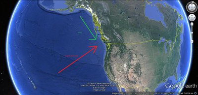
Ok. So most of the time the weather for southwestern Canada comes from the Pacific - around the area of Hawaii. The warm, wet system from Hawaii meets up with colder air coming down the coast from Alaska and they converge offshore. When they meet they head straight inland with a lot of moisture.
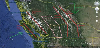
When the storm hits land it has to go over both the Vancouver Island Ranges and the Coast Mountains, which the system usually hits straight on. By the time the storm makes it up and over these ranges it runs out of a lot of steam, creating a rain shadow on the east side of the Coast/Cascade Mountains (so much so that on the east side of the Coast/Cascades down by the border with America it is classified a desert.
The next mountain range is the Columbia Mountains. The southern end of the Columbia's run north/south, have move valleys going through them and aren't as tall of mountains as the north Columbia's, which means that the storm can snake through the mountains, as well as make it easier for the storm to go over. Where, if you go up towards Revelstoke the Columbia's change their angle, the mountains get bigger, and there aren't as many valley's intersecting them. Just south of Revelstoke there is a zone where anywhere south gets less snow than north.
Finally, the storm hits the Rockies, where Nakiska sits. Nakiska is on the east side of the Rockies. By the time the storm gets up and over the spine of the Rockies the system has had to cross 4 major mountain ranges and hits the cold arctic air that sits over central Canada for most of the winter (look at average winter temperatures of Winnipeg for an example of how cold this air can be). An exhausted system meeting really cold air doesn't allow for much for accumulation.