
WHISTLER, BC, January 18, 2012 – Whistler 3D Solutions has updated the 3D Map of Whistler. The Map allows people to learn the layout (and names) of trails, lifts, restaurants, accommodations and other important services in Whistler. The winter map focuses on the ski resort, while the summer map focuses on the mountain biking trails in the valley. Short descriptions are available for some items, which include elevation profiles for the bike trails.
The new user interface offers a full screen map with a navigational menu. The menu allows people to quickly and easily move from one item of interest to the next. A search function is also included to help find items known by name.
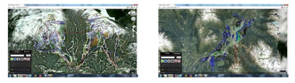
One new feature is the ability to overlay your own GPS tracks (in .kml format). Simply drag and drop your track to see your movements on the map (so you can see exactly where you were). No uploading is required so your travels remain private.
The 3D Map of Whistler was made using Google EarthTM and in order to view the Map, users must download and install the Google Earth Plugin.
A modified version of the map is available for AppleTM and AndroidTM hand held devices. Owners can use the built-in GPS (if available) to locate and correctly orientate themselves while in Whistler.
The new map is available at http://www.3dwhistler.com
Apple, the Apple logo and iPhone are trademarks of Apple Inc., registered in the U.S. and other countries. App Store is a service mark of Apple Inc. Android is a trademark of Google Inc.
About Whistler 3D Solutions
Whistler 3D Solutions was formed in early 2011 by Greg Hildebrand and Mike St Eve. It is based in Whistler, British Columbia, Canada and specializes in creating virtual representations of geographical regions. For more information, please visit whistler3dsolutions.com.
Comments