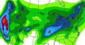
We have a break today before the next storm is ready to dive in tomorrow. This storm will be a much colder storm with a drier & fluffier snow. We could see snow showers start as early as tonight ahead of the main storm. The main storm pushes into the Tahoe basin around noon tomorrow and the heavy snow should last into the evening. With the cold air with this storm and moist flow behind the front I would expect snowshowers to last into Saturday. Total liquid by Saturday is 1-1.25 inches. That is less than the last storm but with colder temps and higher snow ratios we will do pretty good. Looking for 15-20 inches at the base and 20-25 inches on top by Saturday.
The main upper low responsible for spinning the storm in on Friday will move down the coast slowly over the weekend. This could keep snow showers going off and on Saturday and Sunday with several more inches possible. Then the main low pushes in Sunday afternoon into Monday bringing another round of heavier snow. The models have this coming in further North now so this could bring the same amount of snow as the Friday storm with model liquid amounts about the same. The snow showers could linger into Monday night. By Tuesday morning we should have 4 day totals of around 3 feet at the base and 4+ feet on top.
If you thought that was the end you are wrong. A break Tuesday and Wednesday before the next cold storm dives down from the Gulf of Alaska. This storm is being shown by most models as slowing as it approaches and then slowly push inland Thursday-Saturday next week. Looking at snow totals this far out is sketchy but models have enough liquid to bring around 2-3 more feet.
With the ridge sitting out in the Central Pacific over the next 2 weeks we will continue to have a trough along the West coast with fairly cold storms diving in and below average temps. With the March sun we could be in the 40′s in between storms especially at the base but that is below average for this time of year. Long-range models keep the storms coming going towards the end of the month. Looking at teleconnections they look more favorable for storms as we go out 2 weeks. MJO is also circling around and strengthening so we could have one more blast of big storms in the beginning of April. Stay tuned……BA

Comments