We have another cold storm beginning to work its way down the coast off of British Columbia today. That storm will begin to pull in moisture off the ocean and will be sitting off of the Pacific NW coast on Thursday. Snow should begin falling on the mountain during the afternoon on Thursday and will last until Saturday. The heaviest snow will fall Thursday night into Friday. We could clear out as early as Saturday morning but some models have the storm departing a bit slower and the snowshowers sticking around through the day on Saturday.
If you thought the snow with the last storm was light, wait until you see what is coming. The cold with this storm will be as big of a story as the snowfall. Highs in the teens on the mountains Friday and Saturday and lows in the single digits will create snow ratios of 20-30:1. We are going to get some decent snow totals although we are only working with 1-2 inches of liquid. With snow ratios of 20-30:1 throughout the storm we will have snowfall totals of 2-3 feet at the base, and 3-4+ feet on top. There is still a spread in the models on total liquid of about an inch which would be the difference of 3 feet vs. 5 feet on top. I will watch the models closely today to try and figure out if we will get the high or low end of the forecast.
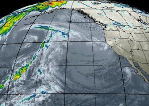
By Sunday & Monday the sun is shining and temps begin to rebound quickly back into the 20′s & 30′s as we get a Southwest flow and a weak ridge ahead of the next storm moving across the Pacific. The pattern next week will be differen’t than what we have seen the past 2 weeks. The ridge wants to setup near the Aleutians or maybe even further North over the Bering Sea. So not only will there be storms coming down the coast from the North, but also from across the Pacific as they can easily pass under the new position of the ridge.
How the storms coming from the two directions interact is the question. The storms coming from West to East across the Pacific will be able to tap into subtropical moisture so they will be strong and much warmer than the storms we have seen. The storms coming down from the North will be cold. It may be the perfect combination as the cold lows from the North can push enough cold into the storms from the West to keep snow levels just at or below lake level.
The models show a train of storms lined up across the Pacific next week, so the way it looks right now we should see a storm every couple of days. I am still not seeing anything long-term that would stop this pattern. The next two weeks should be quite stormy with normal Sierra style snow adding to our already impressive totals. BA
Comments