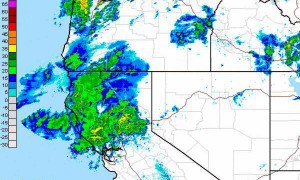
The next storm has already pushed some snow showers over the mountain today as some moisture made its way ahead of the storm. The first heavy wave of the storm will work its way in this evening. The snow level will start off above the base at around 7000 ft. but will fall back to the base overnight. Models are bringing in over 2 inches of liquid along the crest so that should translate to over 2 feet at the summit by Wednesday night.
That is not the end as snow showers move back in on Thursday ahead of the next big storm for Friday. This storm is much colder so the snow won’t be as heavy as the previous storms. This storm will have enough liquid to drop another 18-24 inches. There is a second storm behind that over the weekend that looks to go to our South but the precip could come far enough North to bring several more inches.
Two more storms will come down from the Gulf of Alaska the middel and again at the end of next week. These too are colder storms as we are in a pattern that promotes below average temps and cold storms for the next 10 days. Stay tuned for updates as we go through the week. BA
Comments